
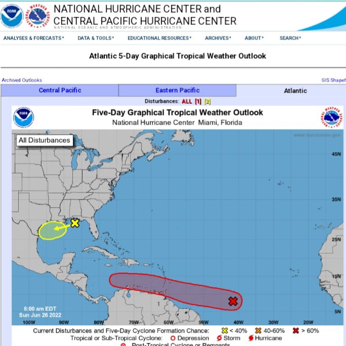
The Barbados Meteorological Services continues to closely monitor the progress of a tropical wave located near 42 to 43 degrees west at 5 am or some one thousand 235 miles east of Barbados.
Meantime, a tropical wave along 56 degrees west will bring cloudy to overcast skies, showers and possible isolated thunderstorms today here in Barbados but is NOT associated with the system the Met Office is closely monitoring.
The further away system has become better organized overnight as a burst of deep convection has formed around the center.
Since yesterday’s statement the system has been tracking westward near 15 miles per hour and this general westward to slightly north of westward motion with an increase in forward speed around tomorrow is expected.
Conditions appear favourable for further development and a tropical depression could form sometime early or by the middle of this week.
Regardless of development, the Barbados Met Office is urging the public to be ready and to remain on the alert for messages from the department and the Department of Emergency Management over this weekend and in particular tomorrow. Marine, excess rainfall, severe thunderstorm and wind alerts remain elevated to yellow level for Tuesday.
This means that the public should be aware that there is the possibility of hazardous weather conditions in the next few days.


One Response
5