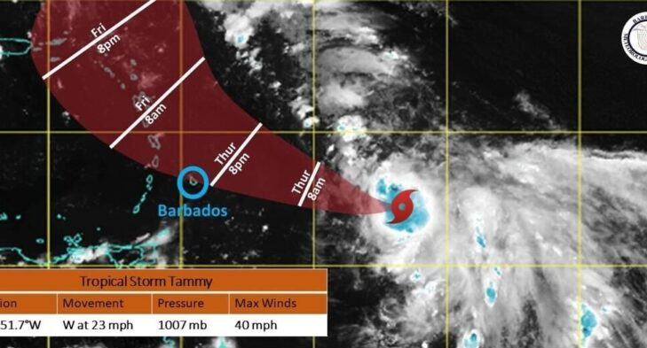
A TROPICAL STORM WATCH IS IN EFFECT FOR BARBADOS AS OF 5PM TODAY
At 5:00 PM, the center of Tropical Storm Tammy was located near 13.0N 51.7W or approximately 575 MI (925 KM) east of Barbados.
Strengthening of the system has occurred over the past few hours with maximum sustained winds estimated near 40 MPH (65 KMH).
Current movement is westward at 23 MPH (37 KMH) with a minimum central pressure of 1007MB.
Expected Impacts:
Marine conditions are forecast to deteriorate from Thursday night 19th October 2023 with moderate to rough swells of 2.5m to 3.0m.
(8ft to 10ft) in open water. As a result, a small craft and high surf advisory is in effect for Barbados.
Possible Impacts for Friday:
As the system is projected to pass north of the island, there is the possibility of occasional gusty winds in moderate to heavy showers associated with feeder bands. Model guidance currently projects rainfall accumulations around 1 to 2 inches with isolated higher amounts.
The public is urged to continue to monitor the progress of this system through updates issued by the Barbados Meteorological Services and follow the guidance and recommendations provided by the Department of Emergency Management.
The next advisory will be issued at 11PM Wednesday 18th October, 2023


