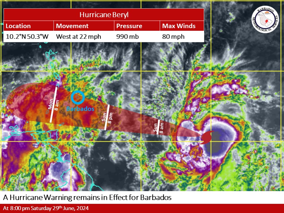
Hurricane Beryl continues to intensify as it is expected to become a major hurricane before reaching Barbados late Sunday night andtherefore a hurricane warning remains in effect for Barbados.On the current projected track, the center of Beryl is expected to pass 55 miles (88 km) south of Barbados. The island is expected to feelthe impacts associated with this system as early as late Sunday night into early Monday morning 1st July, 2024.**** Hazard Info ****Possible ImpactsDuring the passage of Beryl hurricane-force winds and heavy rainfall will cause flash flooding and severe thunderstorm activity is likelyto result in multiple interruptions to power utilities and services. Marine conditions will be hazardous ahead of and during the passage ofBeryl. A small craft and high surf warning remains in effect for above-normal sea swells.What you should doThe public is encouraged to follow the advice provided by the Department of Emergency Management and other local officials inaddition to monitoring the BMS, DEM and GIS websites, their respective social media pages, and the local media networks for furtherinformation on Beryl.DiscussionHurricane Beryl continued to strengthen during the day and at 8 pm today Saturday 29th June, 2024 was located near 10.2N 50.3W orabout 1060 km (660 miles) east-southeast of Barbados. Maximum sustained winds have increased to 80 MPH (130 KM/H). Presentmovement is towards the west at 22 MPH (35 KM/H). The minimum central pressure is 990mb. Hurricane force winds extend outwardup to 20 km (10 miles) from the center and tropical storm force winds extend outward up to 95km (60 miles).General InformationA Hurricane Warning is issued when sustained winds of 64 knots or greater (74 mph; 119kmh) associated with a hurricane are forecastto affect Barbados within 36 hours.